The plan
In 2023 we decided to bike the length of the country, guided by the Tour Aotearoa , but writing some of our own rules and changing the route to fit in with friends and relatives along the way. We don’t carry tents or cooking gear and we need to be able to charge the bikes every night, so that limits us to finding accommodation, preferably self-catering, and food every day.
Our rules
- Off road where possible
- No State Highways unless there are no alternatives. The best roads are gravel with a grass strip down the middle
- No vehicular help except ferries
- Avoid towns and cities where possible (cafes and accommodation excepted)
- Bike for comfort and pleasure. Aim for 60 – 80 km/day
Over the 23/24 summer we did the first section, from Cape Reinga to Auckland, before Christmas, then the rest after school went back, leaving the campgrounds quiet for us.
Read about our bikes and touring gear here
Adding it all up
- 50 biking days
- Nine days with friends and family, and one more sheltering from a storm
- 3090 km
- Total climbing: 32,312 m
- Total downhill: 33,276 m
- Total biking time: 169 hours
- Punctures: 0 (although I did have to put a tube in one tyre when the sealant ran low)
- Days we got wet: one
- Total power used for each bike: 22 KWh. That’s as much as an electric car uses for 110 km, and would cost about $6.60 at the average rate.
– and because I have too much information and a spreadsheet: - Pedal rotations: 670,000
North Island
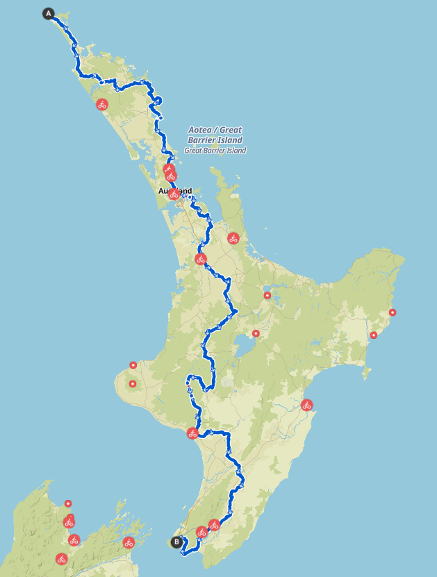
Revised plan – Day 1 & 2:
With hindsight, and if we were doing this again, we would fly AirNZ to Kerikeri with our bikes, courier the batteries up there separately and take a shuttle to the Cape. Some people bike up via Doubtless Bay, stay at Pukenui Motor Lodge, leave their luggage and get a shuttle up and bike back, which is quite a good idea. The road is quiet and it’s about 70 km.
Day 1 – start at the Cape (go down to the light house for your Start Photo), ride down the road to Te Kao or Pukenui
Day 2 – head down to 90 Mile Beach, perhaps at Hukatere, and bike down to Ahipara, which would give you enough of the beach especially if you strike a head wind.
We decided on an East Coast route to Auckland because:
- It is tricky arranging a ferry between Dargaville and Helensville
- the road from Helensville to Auckland is horribly busy
- but mainly, we prefer the East Coast beaches to the Kaipara,
At Kohukohu we broke away from the Tour Aotearoa (TA) route by taking a ferry across with Ranui on Hokianga (phone a few days ahead) to Horeke at the start of the Twin Coast Trail . We did the whole trail in one day thanks to a strong tail wind, and stayed near Kawakawa, but you could easily break it and take longer. Next stop was Oakura, and we were going to carry on via Whananaki and the long skinny walking bridge, but we heard that the Te Araroa trail to Sandy Bay has 5 tall gates, so we took quiet back roads down to Tutukaka, then Whangarei Heads, another ferry to One Tree Point and stayed at Mangawhai, then the last night at Warkworth.
NB: If you are going to bike between Matakana and Warkworth do not attempt it on a weekend. I imagine a weekday afternoon might be safer but it’s a dodgy little piece of road. The Old State Highway 1 down to Orewa is lovely though.
You can almost bypass Auckland by biking directly to Devonport – there’s a harbour side Takapuna Bicycle Path that follows quiet streets and parks that is worth looking for. Take a ferry to the CBD, then another to Pine Harbour and bike around to Clevedon, and you will have avoided nearly all of the city. Here we rejoined the TA route by doing the Hunua Traverse, but not for long, because we opted for the Waikato River Trails instead of the Hauraki Rail Trail because:
- the HRT is a little bit dull with a main road section at the end, which we avoided
- the WRT is varied and takes you all the way to Karapiro
- we had three lots of family to visit along this route
We followed the TA route as closely as we could (some bits are closed off and on) to Arapuni and Mangakino (found some great back roads). From there we took roads including the lovely Ranginui Rd to the Timber Trail, rather than the iconic Arapuni swing bridge route.
At Taumaranui we had a major logistical problem where we had to break one of our rules and took a shuttle – read about it here. We got to the Bridge to Nowhere via the Mangapurua track after staying at the outstanding Ruatiti Backpackers. The track was dry, but it’s a different beast when wet, and we met a group of real TAers who had built loads of character on the official route up the Kaiwhakauka Track, and only one of them had been injured by falling off the very muddy track. You have to book a jet boat to Pipiriki, so do that in advance before you lose phone coverage.
The TA route takes you to Whanganui and then Hunterville, from where we went directly to Ashhurst because there was a problem with accom. at Apiti but I wish we had gone the long way – the Manawatu Cycle Trail sounds lovely and we’ll save it for another trip. We took the slightly illegal but brilliant way through the old gorge road to the Manawatu, then back roads to Ekatahuna, more of them to Greytown and then we diverged again by heading down to Ocean Beach and following the Remutaka Cycle Trail around the foreshore. It was a route we had often looked at, and having done the eastern end of Palliser Bay around to Tora on a previous trip, it completed the south coast route for us. We would have gone right round Pencarrow to Eastbourne, but the road was closed the day before for fire danger, so we had to detour via Wainuiomata.
From there it’s cycleway all the way into the ferry terminal so we skirted Wellington nicely.
South Island
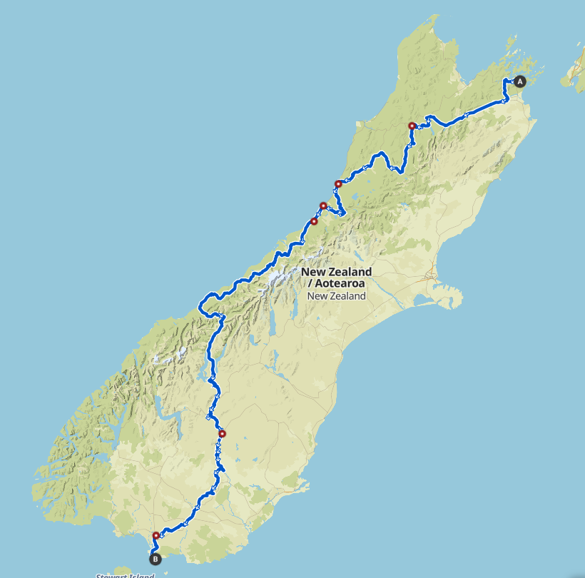
Leaving Picton, we could have have ridden the Link Track but we’ve done it and it was nice, but this time we took advantage of the extensive road works along the Queen Charlotte road which made it great for biking because the cars are only let through in groups and after they’ve gone through there’s no more traffic until the next bunch.
We split from the TA route at Havelock because we wanted to save Nelson/Golden Bay for a more leisurely MH Holiday, and because the Maungatapu track sounded a bit too character building for us with loaded bikes. We have more than enough character, thank you, so we went to St Arnaud via the Wairau Valley with its long straight roads past endless rows of grapes. There’s an alternate route on the other side of the river which involves fords and a currently closed forestry road which would be worth checking out.
After St Arnaud the Porika Track to Lake Rotoroa looked tempting but reviews revealed it to be very steep, muddy and 4WD-worn so we followed the road and enjoyed the Blackburn Track to Murchison. Next day the Maruia Pass was another treat, but we took the road option after Reefton to avoid the Big River Track which is rough and hard with a lot of bike-carrying.
From Greymouth we followed the TA route around the Wilderness Trail to Ross, then on SH 6, taking it slowly in perfect weather with stops at Harihari, Franz Josef, Bruce Bay, Haast and Makarora to Lake Hawea.
We broke away from the TA again at Albert Town to follow the Clutha, first on the Upper Clutha Trail, then the Lake Dunstan Trail, a stopover with friends at Alexandra, then the Roxburgh and Clutha Gold Trails to Miller’s Flat. Ideally we would have have gone all the way the the coast and the Caitlins but weather and time were against us so we turned away from the Clutha at that point to battle headwinds over Moa Flat to Tapanui, (dead interesting) Mataura (that waterfall!), and then to Invercargill, leaving us only a short ride on a bike path in beautiful weather to Bluff and The End