A laid back, old-man-friendly, ebike version of the Tour Aotearoa
We bike for comfort, not for speed, so averaging 60-80km a day is good enough for us. If speed and accomplishment are your style, you could smash this in half the time.
CAUTION: The actual route already differs considerably from this plan. New routes will be posted by early 2024.
Large parts of this route are taken from the real Tour Aotearoa, but since we have the dual constraints of needing to charge our bikes every night and being far too old for camping, we opt for credit card bike packing. This route avoids bigger towns and cities where possible, and minimises contact with Auckland and State Highways. It will take us longer than the 40 odd days listed here because we have friends, family and fun on the way, and we’ll find smaller, less-gravelled roads and tracks as we go.
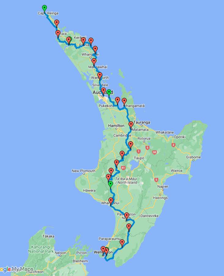
North Island
 / / |
568 km | Up 6,200 | Down 6,310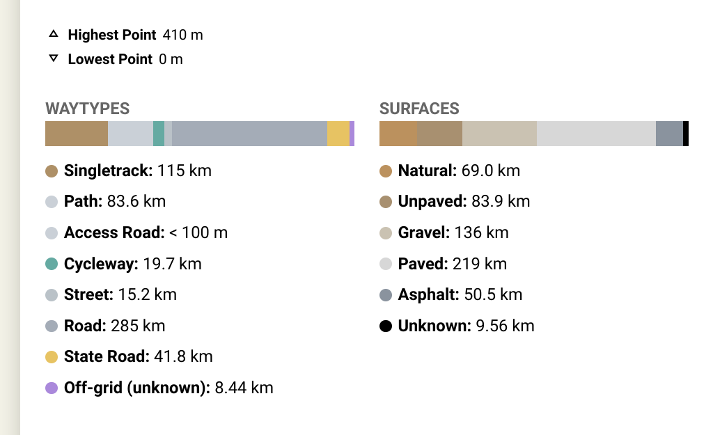 |
 / / |
1,556 km | Up 17,570 | Down 17,710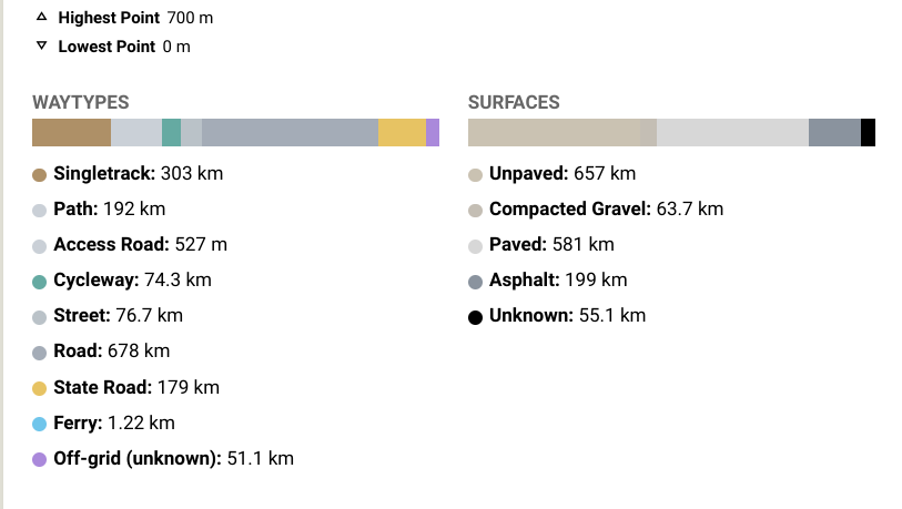 |
South Island
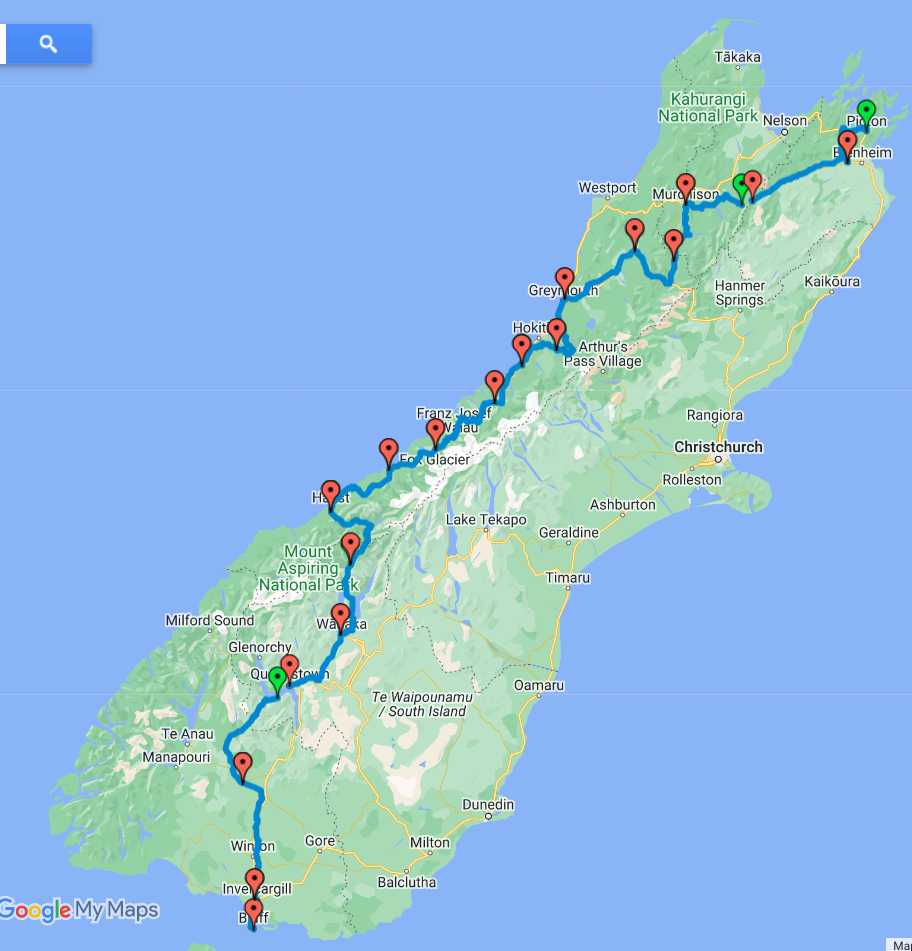 |
1,253 km | Up 12,540 | Down 12,520 |
–>
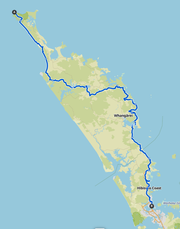
Day 1 | Cape Reinga – Hukatere
Max elevation: 204 m
Min elevation: 0 m
Total climbing: 357 m
Total descent: -460 m
Total time: 05:12:18
Day 2 | Hukatere – Ahipara
Why hurry? When else are you going to ride along a beach like this?
Max elevation: 61 m
Min elevation: 3 m
Total climbing: 45 m
Total descent: -91 m
Total time: 02:50:21
Day 3 | Ahipara – Kohukohu
About here we will depart from the real TA to head down the East Coast to Auckland, thus avoiding the Big Climb past the kauri, Dargavilleand a potentially expensive ferry trip down the big brown Kaipara Harbour. Three wins in one day! There is a ferry from Kohukohu to Horeke, the start of the Twin Coast Trail.
Max elevation: 223 m
Min elevation: 6 m
Total climbing: 863 m
Total descent: -868 m
Total time: 03:39:26
Day 4 | Horeke to Kawakawa
The Twin Coast Trail
Max elevation: 293 m
Min elevation: 6 m
Total climbing: 487 m
Total descent: -483 m
Total time: 04:31:38
Day 5 | Kawakawa to Whananaki
Skipping Russell and the beautiful but hilly coast road which would add about 20km and 200m climbing. Possible fish n chip and recharge at Oakura
Max elevation: 274 m
Min elevation: 5 m
Total climbing: 1113 m
Total descent: -1107 m
Total time: 04:54:36
Day 6 | Whananaki to Whangarei Heads
Taking the ferry from Whangarei Heads to One Tree Point (ph/txt 021 114 7466) means we can completely bypass Whangarei, and a bit of wiggling, almost completely avoid SH1.
Max elevation: 108 m
Min elevation: 2 m
Total climbing: 841 m
Total descent: -836 m
Total time: 04:17:44
Day 7 | One Tree Point to Pakiri
Taking the ferry from Whangarei Heads to One Tree Point (ph/txt 021 114 7466) means we can completely bypass Whangarei, and a bit of wiggling, almost completely avoid SH1.
Max elevation: 114 m
Min elevation: 1 m
Total climbing: 331 m
Total descent: -335 m
Total time: 04:15:54
Day 8 | Pakiri to MAhurangi West
Komoot suggested we bike down Pakiri Beach, so if we wait for the low tide we can miss a heap of rural gravel roads
Max elevation: 412 m
Min elevation: 7 m
Total climbing: 876 m
Total descent: -838 m
Total time: 02:43:53
Day 9 | Mahurangi West to Northcote
Max elevation: 131 m
Min elevation: 2 m
Total climbing: 656 m
Total descent: -653 m
Total time: 02:56:05
Day 10 | Pine Harbour to Kaiaua
This takes in the new Hunua Traverse so that we can avoid the road from Clevedon to Kaiaua which is narrow and busy.
Max elevation: 459 m
Min elevation: 5 m
Total climbing: 1076 m
Total descent: -1074 m
Total time: 04:50:40
Day 11 Kaiaua to Huntly
Max elevation: 172 m
Min elevation: 4 m
Total climbing: 536 m
Total descent: -522 m
Total time: 04:53:11
Day 12 Huntly to Tamahere
Max elevation: 55 m
Min elevation: 15 m
Total climbing: 158 m
Total descent: -130 m
Total time: 02:14:23
Day 13 – 14 Tamahere to Mangakino
Two days, break at Arapuni
Max elevation: 376 m
Min elevation: 34 m
Total climbing: 1195 m
Total descent: -1019 m
Total time: 06:38:08
Back to the Menu
Day 14 | Mangakino to Timber Trail
Max elevation: 703 m
Min elevation: 223 m
Total climbing: 1208 m
Total descent: -919 m
Total time: 04:55:05
Day 15 | Timber Trail to Taumaranui
Max elevation: 632 m
Min elevation: 170 m
Total climbing: 639 m
Total descent: -984 m
Total time: 04:42:58
Day 16 | Taumaranui to Blue Duck
Max elevation: 545 m
Min elevation: 124 m
Total climbing: 845 m
Total descent: -887 m
Total time: 04:33:35
Day 17 | Blue Duck to Bridge to Nowhere
Bookings will be required to get from The Bridge to Nowhere to Pipiriki on the jet boat (fantastic trip). Maybe stay at the Bridge to Nowhere lodge
Max elevation: 631 m
Min elevation: 88 m
Total climbing: 809 m
Total descent: -860 m
Total time: 03:06:18
Day 18 | Pipiriki to Wanganui
Max elevation: 194 m
Min elevation: 4 m
Total climbing: 1007 m
Total descent: -1053 m
Total time: 03:57:17
Day 19 | Wanganui to Palmerston North
The proper TA route goes via Hunterville and down the Manawatu cycle trail which is picturesque but longer, taking 2 days. It could be a good option, especially since it avoids PN altogether
Option A:
Max elevation: 162 m
Min elevation: 2 m
Total climbing: 467 m
Total descent: -435 m
Total time: 04:12:58
Option B:
Max elevation: 680 m
Min elevation: 7 m
Total climbing: 2080 m
Total descent: -2006 m
Total time: 10:29:08
Day 20 | PN to Ekatahuna
Max elevation: 390 m
Min elevation: 39 m
Total climbing: 612 m
Total descent: -425 m
Total time: 04:29:35
Day 21 | Ekatahuna to Greytown
Max elevation: 300 m
Min elevation: 53 m
Total climbing: 267 m
Total descent: -435 m
Total time: 03:25:09
Day 22 | Greytown to Eastbourne
Max elevation: 90 m
Min elevation: 1 m
Total climbing: 465 m
Total descent: -508 m
Total time: 05:35:06
Day 23 | Eastbourne to Ferry
Max elevation: 45 m
Min elevation: 1 m
Total climbing: 121 m
Total descent: -135 m
Total time: 01:01:06
Day 24 | Picton to Renwick
Option A: Includes the next 2 days.
Check the wind direcion here. If it’s not Southeasterly there will probably be a headwind up the Wairau Valley tomorrow.
Max elevation: 254 m
Min elevation: 4 m
Total climbing: 719 m
Total descent: -681 m
Total time: 03:53:31
Option B: [click here] Maybe preferable, but we will take 4 – 5 days for this one with a rest day in Nelson – maybe longer if we decide to do some of the Great Taste Trails
Max elevation: 979 m
Min elevation: 2 m
Total climbing: 4000 m
Total descent: -3848 m
Total time: 16:38:31
Day 25 | Renwick to St Arnaud
Max elevation: 665 m
Min elevation: 39 m
Total climbing: 791 m
Total descent: -216 m
Total time: 05:48:39
Day 26 | St Arnaud to Murchison
Max elevation: 978 m
Min elevation: 171 m
Total climbing: 890 m
Total descent: -1360 m
Total time: 04:06:50
Day 27 | Murchison to Maruia
Max elevation: 596 m
Min elevation: 171 m
Total climbing: 810 m
Total descent: -629 m
Total time: 03:45:22
Day 28 | Maruia to Reefton
Max elevation: 691 m
Min elevation: 199 m
Total climbing: 488 m
Total descent: -643 m
Total time: 03:37:52
Day 28 | Reefton to Greymouth
Max elevation: 285 m
Min elevation: 7 m
Total climbing: 423 m
Total descent: -612 m
Total time: 03:50:53
Day 30 | Greymouth to Kaniere
Max elevation: 350 m
Min elevation: 2 m
Total climbing: 615 m
Total descent: -482 m
Total time: 05:05:02
Day 31 | Kaniere to Ross
Max elevation: 149 m
Min elevation: 7 m
Total climbing: 188 m
Total descent: -304 m
Total time: 03:00:15
Day 32 | Ross to Harihari
Max elevation: 121 m
Min elevation: 7 m
Total climbing: 262 m
Total descent: -240 m
Total time: 02:28:02
Day 33 | Harihari to Fox Glacier
Max elevation: 436 m
Min elevation: 45 m
Total climbing: 1266 m
Total descent: -1137 m
Total time: 04:34:08
Day 34 | Fox to Bruce Bay
Max elevation: 186 m
Min elevation: 9 m
Total climbing: 237 m
Total descent: -412 m
Total time: 02:13:43
Day 35 | Bruce Bay to Haast
Max elevation: 214 m
Min elevation: 9 m
Total climbing: 660 m
Total descent: -656 m
Total time: 03:47:10
Day 36 | Haast to Makarora
Max elevation: 590 m
Min elevation: 17 m
Total climbing: 1195 m
Total descent: -877 m
Total time: 04:19:47
Day 37 | Makarora to Wanaka
Max elevation: 444 m
Min elevation: 282 m
Total climbing: 634 m
Total descent: -646 m
Total time: 03:47:02
Day 38 | Wanaka to Queenstown
Max elevation: 1090 m
Min elevation: 294 m
Total climbing: 998 m
Total descent: -938 m
Total time: 04:03:00
Day 39 | Queenstown to Mossburn
Max elevation: 811 m
Min elevation: 298 m
Total climbing: 871 m
Total descent: -890 m
Total time: 06:41:57
Day 40 | Mossburn to Invercargill
Max elevation: 297 m
Min elevation: 3 m
Total climbing: 56 m
Total descent: -342 m
Total time: 05:50:57
Day 41 | Invercargill to Bluff
Max elevation: 21 m
Min elevation: 1 m
Total climbing: 59 m
Total descent: -54 m
Total time: 01:29:53
Picton to Murchison via Nelson
Picton to Pelorous
Max elevation: 254 m
Min elevation: 4 m
Total climbing: 753 m
Total descent: -731 m
Total time: 03:56:47
Pelorus to Nelson
Max elevation: 737 m
Min elevation: 13 m
Total climbing: 961 m
Total descent: -1037 m
Total time: 02:25:03
Back to the Menu
Nelson to Tapawera
Max elevation: 349 m
Min elevation: 8 m
Total climbing: 554 m
Total descent: -408 m
Total time: 03:48:19
Tapawera to Murchison
Max elevation: 488 m
Min elevation: 151 m
Total climbing: 724 m
Total descent: -710 m
Total time: 04:56:29
Hunterville to Ashhurst
Max elevation: 428 m
Min elevation: 81 m
Total climbing: 553 m
Total descent: -739 m
Total time: 03:26:12
Hunterville to Apiti
Max elevation: 680 m
Min elevation: 177 m
Total climbing: 946 m
Total descent: -747 m
Total time: 04:01:12
Apiti to Ashhurst
Max elevation: 551 m
Min elevation: 82 m
Total climbing: 396 m
Total descent: -777 m
Total time: 03:16:55